After post-processing some of the raw data from the Perdigão experiment, conducted by researchers from DTU Wind Energy in May till June of this year, a real-world visualisation of the acquisition method was created, giving a first impression of the air flow in mountainous terrain and its interaction with a wind turbine. It furthermore highlights the great potential of the WindScanner measurement system.
The experiment was organised within the New European Wind Atlas project to establish a new reference measurement database for flows in complex terrain. The site in Perdigão, Portugal, was ultimately selected, due its two almost perfectly parallel running ridges oriented along a north-westerly axis.
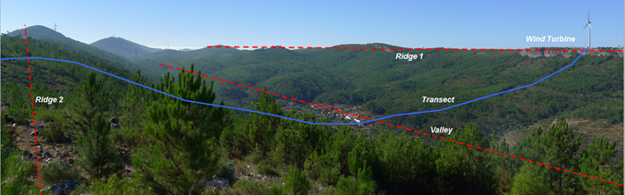
The Perdigão site (courtesy of N. Vasiljevic)
The great novelty of this measurement campaign stems from deploying the most advanced measurement technologies on a previously unseen scale. For the first time both the Short- and Long – Range WindScanner systems, developed at DTU Wind Energy, were measuring on the same flow at the same time. Both these systems are made up of three wind speed sensing lasers. Employing three synchronized lasers allows reconstructing 3-D velocity vectors, offering the possibility of gaining deeper insight into complex flows, as those found in mountainous areas.
While several researchers are feverishly post-processing all the data acquired during this campaign, the Numerical Modeling group of UniTTe has been asked to analyse and process some of the already available data. Although only 22 minutes from the Short-Range WindScanner were analysed, the first impressions are hinting at an invaluable dataset. Vast quantities of impressive flow features were already registered in this rather short time period. A video of this first measurement period can be found here.
Over the next couple of months more data will become available, enabling a quantification of the exact interaction between the complex terrain and the wind turbine. In UniTTe the focus will lie on the impact of complex terrain on the turbine induction zone and its potential consequences for nacelle mounted lidars. Simultaneously the WindScanner data will be used for computational model validation.